

ゴルフな日Su ゴルフナビ GPS 計測
by MAPPLE ON Co., Ltd.
"Golf Day Su" is a full-scale GPS golf navigation app that allows you to see "height difference" and "wind direction".

ゴルフな日Su ゴルフナビ GPS 計測
using the course map adopted for the golf navigation dedicated machine (commercially available) as well as our conventional application (GOLF day) We strongly support golfers as a "Golf Navi GPS" app.■ Major courses for overseas resorts (Hawaii, Guam, Saipan, Thailand) have been added.[Caution] We do not accept data updates or corrections for overseas courses.
Please note that the actual course may differ when used.
In addition, overseas courses do not support height difference data or weather information.~ Main features of Golf Day Su ~① Golf course information is free to browseBrowsing golf course information is free, which is convenient for checking phone numbers and locations.(* As of March 31, 2017, the distribution of Mapples golf course guide has ended.)② Adopt original course mapThe course map is made by Yupiteru Co., Ltd., which is familiar with golf navigation dedicated machines (ATLAS series).
We maintain data on more than 2,350 original golf courses nationwide (99% in Japan).* Course map data is updated regularly at least once a month.
Please contact us if there is a golf course that has changed course.
You can check the update status in the in-app notification or on the official website.* Course map data can be used without restrictions as long as it is within the valid period for which you have purchased a monthly subscription ticket.
(Cannot be used if the validity period has expired.) ④ No communication requiredSince the course map can be downloaded to the terminal in advance and used, you can use it with confidence without worrying about the radio wave condition during play.
However, the validity period of the billing account check is set within 24 hours, so if you use it at a golf course with poor radio wave conditions, 1 in advance (within 24 hours) where the radio wave reaches, such as at home.
Please use after displaying the course map.
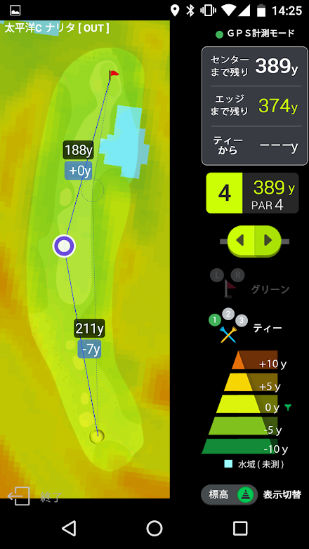
When you display the course map, the billing check will be performed automatically.⑤ Distance display to hazardThe course map data also includes data for displaying the distance to the edge in front of the green and the remaining distance to hazards such as bunkers and ponds.⑥ Equipped with automatic hole feed functionIf you start in the automatic hole feed mode, the hole will be judged near the tee ground and the map will automatically switch to the target hole.Furthermore, it also supports Android Wear, and when started in automatic hole feed mode, the remaining distance is transferred to the paired Wear side, so you can use it with the smartphone body in your pocket.⑦ Equipped with high / low graph functionA function to display the elevation data in the hall map as a graph (mesh & step color).
Not only the height difference to the green, but also the height difference can be measured at the time of tee shot and layup.There are two types of elevation data, 5m mesh and 10m mesh.* The accuracy of the 10m mesh is rougher and the error is larger.
)⑧ Equipped with wind direction meter functionIt is a function to solve "Which is the south-southeast wind?" The "wind in the sky" obtained from the latest and latest weather forecast is displayed by the arrow along the hall map.You can use it as reference information when calculating the wind by visually displaying the wind in the sky (previous forecast) that is invisible to the eye and difficult to experience.* Wind direction and speed are forecast values, so they may differ from the actual wind.* The wind on the ground surface changes greatly depending on the terrain.⑨ Equipped with pinpoint weather forecast for each golf courseWe provide pinpoint forecast information about temperatures and weather that are slightly different for each golf course.⑩ Layup functionWhen you press the point you want to lay up in the hole map in GPS measurement mode or automatic hole feed mode, the distance from the current position (red circle) acquired by GPS to the layup point (blue circle) is displayed.This layup function will be automatically canceled if you do not touch the hole map for 10 seconds.⑪ Compatible with smart watchesIf you use the interlocking function with a wristwatch-type smart watch (only compatible with WearOS 1.x terminals), you can check the remaining distance even if you keep your smartphone in your pocket.* Support for WearOS 2.x terminals is undecided.
(As of May 2021)* Course map display support is a limited function of Apple Watch terminals.
Please note that Wear OS does not support it.■ Premium member・ It is a plan that you can use all the functions anywhere in the country for 360 yen (tax included) per month.-------------------------------■ Supported OS・ This application is compatible with Android OS 4.1 or later.* Please note that support is not available for models other than those supported above.・ GPS measurement mode cannot be used on terminals without GPS.-It does not work properly on screen slide type and separate (two screen) type terminals.* In addition, it may not work on some models.■ About automatic hole judgment・ The automatic hole is not judged in the middle of a hole such as a fairway, so if you start from the middle, please switch manually.-Please note that the automatic hole feed function uses GPS in the background and consumes a lot of battery.■ About updating the course map・ The course map will be updated one by one.
Please contact us if there is a change in the layout of the course.
You can check the update status in the in-app notification or on our website.■ About GPS measurement・ Before using, make sure that "Location services (GPS)" is turned on in "Settings" of the terminal.・ Large errors may occur due to weather and obstacles (power transmission lines, etc.).・ GPS measurement consumes a lot of battery.
Please use it with settings that reduce other power consumption, such as turning off the Wi-Fi connection during play.・ If you are out of service area or turn off the network line, it may take several minutes to acquire GPS satellites because A-GPS cannot be used.・ GPS performance depends on the model and OS.
Please note that we cannot accept compensation or refund for troubles caused by GPS performance or other damages caused by this application.・ The billing contract will not be canceled even if you uninstall the app.・ Golf Day Su does not have a voice assist option.The voice assist option can be used on the conventional version of "Golf Day".不具合修正
About ゴルフな日Su ゴルフナビ GPS 計測
- Package name (App ID)
- jp.mappleon.golfnavisu
- Available on
- Google Play
- Price
- Free
- Updated
- December 15, 2021
- Developer
- MAPPLE ON Co., Ltd.
Looking for the ゴルフな日Su ゴルフナビ GPS 計測 APK?
The safest way to get ゴルフな日Su ゴルフナビ GPS 計測 (jp.mappleon.golfnavisu) on your Android device is to install it directly from Google Play — you'll always get the latest official version, automatic updates, and no risk of modified or infected APK files from third-party sites.

Social Features
Connect and share with friends and the community.
Gaming Features
Enjoy immersive gaming experience with various game modes.
Weather Features
Get accurate weather forecasts and real-time updates.
See ゴルフな日Su ゴルフナビ GPS 計測 in Action


Frequently Asked Questions
Is ゴルフな日Su ゴルフナビ GPS 計測 free?
Yes, ゴルフな日Su ゴルフナビ GPS 計測 is free to download and install on Android through Google Play.
How do I install ゴルフな日Su ゴルフナビ GPS 計測 on Android?
Open Google Play on your Android phone or tablet, search for ゴルフな日Su ゴルフナビ GPS 計測 by MAPPLE ON Co., Ltd. or tap the Google Play button on this page, then tap Install. The app downloads and installs automatically.
What is jp.mappleon.golfnavisu?
jp.mappleon.golfnavisu is the App ID (package name) of ゴルフな日Su ゴルフナビ GPS 計測 on Google Play. Every Android app has a unique package name, and it is the safest way to verify you are installing the official app.
Is ゴルフな日Su ゴルフナビ GPS 計測 safe to download?
Installing ゴルフな日Su ゴルフナビ GPS 計測 from Google Play is the safest option: you get the official version published by MAPPLE ON Co., Ltd., verified by Google Play Protect, with automatic updates. Avoid APK files from unofficial third-party sites.
Get ゴルフな日Su ゴルフナビ GPS 計測 Today
ゴルフな日Su ゴルフナビ GPS 計測 for Android — free download on Google Play.
Compatible with Android phones and tablets — available on Google Play.
Ask AI about this app
Get instant answers about features, tips and more from popular AI assistants.